Ben Nevis - 1343 metres
The first recorded ascent of Ben Nevis was made on 17 August 1771 by James Robertson, an Edinburgh botanist, who was in the region to collect botanical specimens.
It was not until 1847 that Ben Nevis was confirmed by the Ordnance Survey as the highest mountain in Britain, ahead of its rival Ben Macdui.
The summit observatory was built in the summer of 1883, and would remain in operation for 21 years. The first path to the summit was built at the same time as the observatory and was designed to allow ponies to carry up supplies, with a maximum gradient of one in five. The opening of the path and the observatory made the ascent of the Ben increasingly popular, all the more so after the arrival of the West Highland Railway in Fort William in 1894.
Our Route:
The 1883 Pony Track to the summit (also known as the Ben Path, the Mountain Path, or the Tourist Route) remains the simplest and most popular route of ascent. It begins at Achintee on the east side of Glen Nevis about 2 km (1.5 miles) from Fort William town centre, at around 20 metres above sea level.
The path starts off gently from the Glen Nevis Visitor Centre via a bridge crossing the River Nevis and
affords easy walking before climbing steeply to the saddle by Lochan Meall an t-Suidhe at 570m, and then ascends the remaining 700 metres up the stony west flank of Ben Nevis in a series of zig-zags. It is well made and maintained throughout its length, and, thanks to the zig-zags, not unusually steep apart from the initial stages.
- Start / Finish: Glen Nevis Visitor Centre Car Park
- Ascent: 4350 feet
- Target time: Ascent: 2.5 - 3 hour / Descent: 2 - 2.5 hours
Ben Nevis, although not as high as Alpine mountains, is positioned on a more northerly latitude and the climate can be considered similar to Arctic regions.
While there may be a welcoming sea breeze on the shores of Loch Linnhe, 20-30 knots of chilling wind may be evident on the summit of the Ben. Many walkers/climbers find weather conditions changing within minutes - usually for the worse - as they work their way up the mountain.
The dramatic effect of Ben Nevis, Britain's highest mountain, is emphasised by the fact that it begins its rise from sea-level on the shores of Loch Linnhe, to tower 4,406ft (1,344m) above the town of Fort William, providing an almost paternal presence.
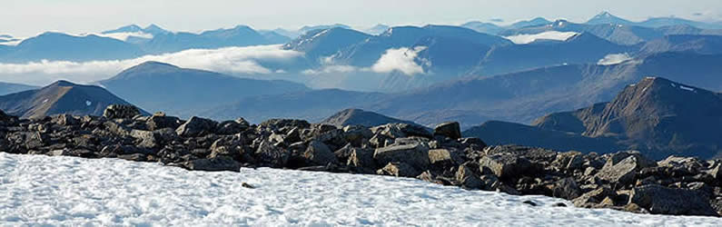
The view from Britain's highest point is extensive and in ideal conditions it can extend up to 190 km (120 miles), including such mountains as the Torridon Hills, Morven in Caithness, Lochnagar,
Ben Lomond, Barra Head, and 123 miles (198 km) to Knocklayd in County Antrim, Ireland.
|